
Gaborone

| Year dem found am | 1965 |
|---|---|
| Native label | Gaborone, Gaborone, Gaborone, Gaborone |
| Dem name after | Kgosi Gaborone |
| Demonym | gaboronais, gaboronaise, Gaberonano, Gaboronais, Gaboronaise |
| Country | Botswana |
| Capital of | Botswana, Bechuanaland Protectorate |
| Edey de administrative territorial entity insyd | South-East District |
| Located in time zone | Central Africa Time, UTC+02:00 |
| Coordinate location | 24°39′25″S 25°54′31″E |
| Twinned administrative body | Burbank, Zhejiang, Västerås Municipality, Sorong, Windhoek |
| Dema official website | http://www.gov.bw/en/Ministries--Authorities/Local-Authorities/Gaborone-City-Council |
| Local dialing code | 00267 |
| Category for maps or plans | Category:Maps of Gaborone |

Gaborone be de capital den largest city of Botswana plus population of 246,325 base for de 2022 census,[1] about 10% of de total population of Botswana.[2] Ein agglomeration be home to 421,907 inhabitants at de 2011 census.
Gaborone dey situate between Kgale Hill den Oodi Hill, near de confluence for de Notwane River den Segoditshane River for de south-eastern corner for Botswana, 15 kilometres (9.3 mi) from de South African border.[3] Sir Seretse Khama International Airport wey dey serve de city. Ebe administrative district for ein own right, but ebe de capital for de surrounding South-East District.[4] Locals often dey refer de city as GC anaa Motse-Mshate.[5]
Den name de city of Gaborone after Chief Gaborone of de Tlokwa tribe, wey na once he control near nearby land.[6] Secof e no get tribal affiliation wey na e dey close to fresh water, dem plan de city make ebe de capital for de mid-1960s wen na de Bechuanaland Protectorate cam turn independent nation.[6] De centre of de city be long strip of commercial businesses, dem call am "Main Mall" plus semicircle-shaped area of government offices wey dey ein east. Na Gaborone once be one of de fastest-growing cities for de world insyd, wey dis create problems plus housing den illegal settlements. De city san so deal plus conflicts wey dey spill cam de country insyd from Zimbabwe den South Africa during de 1980s.
Gaborone be de economic capital den de government capital; ebe headquarters to chaw companies den de Botswana Stock Exchange. Gaborone san so be home give de Southern African Development Community (SADC), regional economic community dem establish for 1980 insyd.[7] Dem dey speak chaw languages for der, Setswana (Tswana) be de main tongue. Dem san so dey speak English, Kalanga, den Kgalagadi.
History
[edit | edit source]Geography
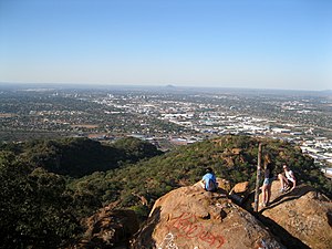
[edit | edit source]Gaborone dey situate for 24°39′29″S 25°54′44″E between Kgale den Oodi Hills, for de Notwane River for de south-eastern corner of Botswana insyd, den 15 kilometres (9.3 mi) from de South African border.[3] De city dey lie for elevation of 1,010 metres (3,310 ft) above sea level. De cities wey dey follow surround Gaborone: Ramotswa go de southeast, Mogoditshane go de northwest, den Mochudi go de east, den Tlokweng across de river. Chaw of dem be commuter towns give Gaborone. Suburbs for Gaborone insyd dey include Broadhurst, Gaborone West, The Village, Naledi.[3] Phakalane, affluent suburb, dey lie about 13 km north of de city center.[8]
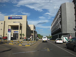
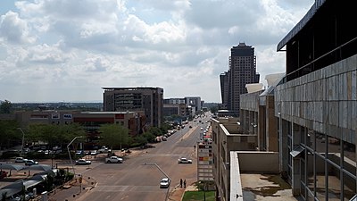
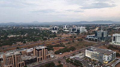
For de centre of de city dey lie Main Mall wey dey house chaw diplomatic missions. For de eastern end of de Mall, one fi find de Civic Centre along plus de Pula Arch wey dey commemorate Botswana ein independence. De Botswana Stock Exchange, National Museum and Art Gallery, den de main campus of de University of Botswana san so dey lie near de Main Mall. Go de west of de Main Mall be de Government Enclave. Dis area dey contain de governmental buildings lyk de National Assembly of Botswana den Ntlo ya Dikgosi buildings. Dem san so fi find de National Archives for here.
|
| ||||||||||||||||
|---|---|---|---|---|---|---|---|---|---|---|---|---|---|---|---|---|
| ||||||||||||||||
Climate
[edit | edit source]| Climate data for Gaborone (Sir Seretse Khama Airport, 1981–2010) | |||||||||||||
|---|---|---|---|---|---|---|---|---|---|---|---|---|---|
| Month | Jan | Feb | Mar | Apr | May | Jun | Jul | Aug | Sep | Oct | Nov | Dec | Year |
| Record high °C (°F) | 39
(103) |
40
(104) |
39
(102) |
37
(98) |
33
(91) |
29
(84) |
28
(83) |
33
(91) |
39
(103) |
38
(100) |
40
(104) |
39
(103) |
40
(104) |
| Average high °C (°F) | 32.7
(90.9) |
32.1
(89.8) |
30.8
(87.4) |
28.4
(83.1) |
25.6
(78.1) |
23.1
(73.6) |
22.9
(73.2) |
26.2
(79.2) |
30.0
(86.0) |
32.0
(89.6) |
32.3
(90.1) |
32.5
(90.5) |
29.1
(84.4) |
| Daily mean °C (°F) | 25.7
(78.3) |
25.2
(77.4) |
23.7
(74.7) |
20.6
(69.1) |
16.8
(62.2) |
13.7
(56.7) |
13.5
(56.3) |
16.9
(62.4) |
21.2
(70.2) |
24.0
(75.2) |
24.7
(76.5) |
25.3
(77.5) |
20.9
(69.6) |
| Average low °C (°F) | 19.7
(67.5) |
19.3
(66.7) |
17.4
(63.3) |
13.5
(56.3) |
8.3
(46.9) |
5.0
(41.0) |
4.4
(39.9) |
7.5
(45.5) |
12.3
(54.1) |
16.3
(61.3) |
17.7
(63.9) |
18.8
(65.8) |
13.4
(56.1) |
| Record low °C (°F) | 14
(57) |
13
(55) |
11
(52) |
0
(32) |
−1
(30) |
−1
(30) |
−2
(28) |
0
(32) |
5
(41) |
7
(45) |
8
(46) |
11
(52) |
−2
(28) |
| Average precipitation mm (inches) | 143
(5.6) |
82
(3.2) |
74
(2.9) |
30
(1.2) |
8.3
(0.33) |
7.5
(0.30) |
1
(0.0) |
0.9
(0.04) |
5.8
(0.23) |
5.8
(0.23) |
58
(2.3) |
71
(2.8) |
487.3
(19.13) |
| Average rainy days | 6 | 5 | 5 | 3 | 2 | 1 | 1 | 1 | 2 | 4 | 5 | 6 | 41 |
| Source 1: African Regional Climate Centre[9] | |||||||||||||
| Source 2: Weatherbase (records)[10] | |||||||||||||
Demographics
[edit | edit source]De population, base for de 2022 census top, be 246,325. Der be 118,727 males den 127,598 females for de city insyd.[11] Der be 58,476 households for Gaborone insyd.[12] For 2011 insyd, na de average household size be 3.11 people. De city of Gaborone be home give ova 10% of de population of Botswana.[2][13] Almost half of Botswana citizens dey live within 100 kilometres (62 mi) of Gaborone.[14]
Places of worship
[edit | edit source]Culture
[edit | edit source]Economy
[edit | edit source]Sport
[edit | edit source]| Venue | Sport | Capacity | Club(s) | |
|---|---|---|---|---|
| Botswana Cricket Association Oval | Cricket | n/a | Botswana cricket team | |
| Botswana National Stadium | Football, Athletics, Rugby, Tennis | 25,000 | Gaborone United, Notwane F.C.,
Police XI, Township Rollers F.C. | |
| Mochudi Stadium | Football | 10,000 | Mochudi Centre Chiefs | |
| SSKB Stadium | Football | 5,000 | Botswana Defence Force XI | |
| University of Botswana Stadium | Football | 5,000 | Uniao Flamengo Santos F.C. |
Parks den recreation
[edit | edit source]Wildlife
[edit | edit source]De Gaborone Game Reserve be 600-hectare (1,500-acre) park east of de city for Limpopo Drive.[17] Dem build de city for 1988 insyd wey now ebe de third-busiest for Botswana insyd. Examples of animals for de park insyd be impala, kudu, ostriches, wildebeest, zebras, gemsbok, bushbuck, springbok, duiker, common eland, den common warthogs.[18] De park be destination give birdwatching.[19] Birds for de marshy section for de park insyd dey include snake eagles, boubou, gallinule, kingfishers, den hornbills.[18]
Government
[edit | edit source]Local government
[edit | edit source]National government
[edit | edit source]Education
[edit | edit source]De main campus of de University of Botswana (wich na dem establish insyd 1982)[20] be for de eastern extent of de city top.[17]
For addition der be oda universities anaa institutions of higher education wey dey cater to specialized study den instruction.
- Limkokwing University Of Creative Technology (wich sanso get campus insyd Gaborone)
- Botswana Accountancy College (wich dey cater to both accounting den IT students)
- Botswana Institute of Administration and Commerce[21]
- Botswana Open University (dey offer long-distance learning)
- Gaborone Technical College
- Boitekanelo College
- Botho University (wich dey offer courses wey dey range from computing, accounting den finance, business, engineering den health information management)
- Botswana University of Agriculture and Natural Resources, situate approximately 15 kilometres (9.3 mi) from de city centre[22]
Further, insyd year 2006, de Gaborone Universal College of Law, gbele ein main campus insyd Gaborone,[23] plus ein first group of students wey graduate insyd 2010.[24]
Media
[edit | edit source]Newspapers dem publish for Gaborone insyd dey include Mmegi, The Botswana Gazette, The Monitor, Midweek Sun, The Patriot for Sunday, Sunday Standard, den The Voice. Magazines dem publish be Lapologa, Peolwane, Kutwlano among odas.
Infrastructure
[edit | edit source]Utilities
[edit | edit source]Healthcare
[edit | edit source]HIV/AIDS
[edit | edit source]Transportation
[edit | edit source]Railways
[edit | edit source]Airports
[edit | edit source]Roads
[edit | edit source]Highways for insyd den around Gaborone dey include de Trans-Kalahari Highway, A1 Highway, A10 Highway den de Cairo-Cape Town Highway. Five major roads wey dey for Gaborone insyd wey dey go Lobatse, Kanye, Molepolole, Francistown via Mochudi, den Tlokweng.[25]
Public transport
[edit | edit source]- Kombi
Public transport for de city be generally reliable, when dem compare plus major African cities. Kombis (small vans) den taxis dey ply de routes within de city, while buses dey serve surrounding villages den oda towns for Botswana insyd.[3]
Private traffic
[edit | edit source]Notable people
[edit | edit source]- Kgosi Gaborone (c. 1825–1931), Motswana chief, after whom dem name de city
- Alec Campbell (1932–2012), archaeologist den museum curator
- Thamsanga Mnyele (1948–1985), member of de African National Congress den artist
- Vernon Nkadimeng (1958–1985), member of de African National Congress, de apartheid police kill am for Gaborone insyd
- Boniface Tshosa Setlalekgosi (b. 1927), Roman Catholic bishop of de Diocese of Gaborone, Botswana from 1981 come 2009
- Wally Serote (b. 1944), poet den anti-apartheid activist
- Dipsy Selolwane (b. 1978), football player
- Mpule Kwelagobe (b. 1979), Miss World Botswana 1997, Miss Universe Botswana 1999 den Miss Universe 1999
- Alister Walker (b. 1982), squash player
- Abednico Powell (b. 1983), football player
- Joel Mogorosi (b. 1984), football player
- Dirang Moloi (b. 1985), member of de Botswana national football team
- Donald Molosi (b. 1985), actor, writer den playwright wey attend Maru a Pula School for ein teens insyd,[26] den de National Arts Festival for South Africa insyd[27]
- Sumaiyah Marope (c. 1987), Miss Botswana 2009
- Emma Wareus (b. 1990), Miss World Botswana 2010, first runner-up to Miss World 2010
- Matsieng, Setswana traditional music group, dem form for Gaborone for 2005 insyd
International relations
[edit | edit source]Dem twin Gaborone plus:
- Burbank, United States[28]
- Sorong, Indonesia[29]
- Worcester, South Africa[29]
- Walvis Bay, Namibia[29]
Gallery
[edit | edit source]-
 Flag map of Gaborone
 -
 Street scene near de Main Mall
 -
 Rhodesia Railways car at de national museum
 -
 View from Kgale Hill (Oodi Hill for horizon)
 -
 Gaborone Dam
 -
 Gaborone Dam
 -
 Botswana Gaborone I Towers
 -
 Gaborone Hindu Temple
 -
 Gaborone Mosque
 -
 CBD
CBD -
 CBD Developments
 -
 New Construction Developments
 -
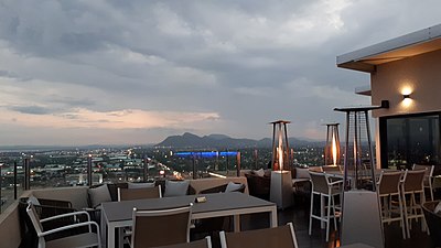 Room 52 Roof Top Restaurant
 -
 New CBD
 -
 Christ The King Cathedral
 -
 CBD Mall
 -
 SSKI Airport


References
[edit | edit source]- ↑ "Statistics Bostwana - Census 2022 - Population of cities, towns and villages" (PDF).
- ↑ 2.0 2.1 Central Statistics Office (January 2009). "Botswana Demographic Survey 2006" (PDF). Gaborone, Botswana. Archived from the original (PDF) on 23 September 2016. Retrieved 3 July 2010.
- ↑ 3.0 3.1 3.2 3.3 Seth, Willie (2008). "Major urban centres". Botswana and Its People. Godfrey Mwakikagile. pp. 44–46. ISBN 978-0-9814258-7-0. Retrieved 4 August 2009.
- ↑ Laws of Botswana Archived 23 July 2011 at the Wayback Machine, Ministry of Local Government Archived 18 July 2009 at the Wayback Machine
- ↑ Njeru, Purity (2009). "History of Gaborone". Nairobi, Kenya: The African Executive. Archived from the original on 7 July 2011. Retrieved 4 August 2009.
- ↑ 6.0 6.1 "Map - Gaborone - MAP[N]ALL.COM". 174.127.109.64. Retrieved 30 May 2020.
- ↑ "Southern African Development Community :: About SADC". www.sadc.int. Archived from the original on 12 March 2018. Retrieved 28 April 2018.
- ↑ Phakalane Properties (2008). "Gaborone Information – Phakalane Properties, Botswana". Phakalane, Botswana. Archived from the original on 18 April 2011. Retrieved 24 May 2011.
- ↑ "Precipitation and temperature reference climatologies: Seretse Khama International Airport". African Regional Climate Centre. Archived from the original on 14 March 2016. Retrieved 19 January 2016.
- ↑ "Weatherbase: Historical Weather for Gaborone, Botswana". Weatherbase. Archived from the original on 24 September 2012. Retrieved 26 June 2012.
- ↑ "Statistics Botswana - Census 2022 - Population of cities, towns and villages" (PDF).
- ↑ Central Statistics Office (7 February 2008). "Table 1.1: Population by sex and census districts (1991 And 2001)". Gaborone, Botswana. Archived from the original on 13 November 2009. Retrieved 5 August 2009.
- ↑ LeVert, Suzanne (2007). Botswana. Marshall Cavendish. pp. 15, 27–28, 105. ISBN 978-0-7614-2330-0. Retrieved 6 August 2009.
- ↑ Jefferis, Keith; Pickering, Dawn; Kenwendo, Bogolo (2010). "Botswana Country Overview 2010/11" (PDF). Botswana Resource Conference 2010. Capital Resources. Archived from the original (PDF) on 4 September 2015. Retrieved 24 May 2011.
- ↑ "Stadiums in Gaborone". worldstadia.com. 2010. Archived from the original on 31 December 2010. Retrieved 1 July 2010.
- ↑ "Stadiums in Botswana". World Stadiums. 2010. Archived from the original on 6 October 2009. Retrieved 1 July 2010.
- ↑ 17.0 17.1 Gaborone City map (Map). Botswana Maps. Botswana Tourism Board. 2001. Archived from the original on 8 November 2016. Retrieved 4 August 2009.
- ↑ 18.0 18.1 Hardy, Paula; Firestone, Matthew D. (2007). "Gaborone". Botswana & Namibia. Lonely Planet. pp. 75–88. ISBN 978-1-74104-760-8. Retrieved 4 August 2009.
- ↑ "Gaborone Holidays – a Visit to the Vibrant Cosmopolitan Capital". 24 May 2006. Archived from the original on 25 June 2010. Retrieved 5 August 2009.
- ↑ Seth, Willie (2008). "Major urban centres". Botswana and Its People. Godfrey Mwakikagile. pp. 44–46. ISBN 978-0-9814258-7-0. Retrieved 4 August 2009.
- ↑ "General Information". gov.bw via Wikiwix. Archived from the original on 9 April 2005. Retrieved 13 October 2023.
- ↑ "BCA becomes university", Daily News, Gaborone, Botswana, 12 November 2013, archived from the original on 1 July 2016, retrieved 4 April 2016
- ↑ "About Us". Gaborone, Botswana: Gaborone Universal College of Law. Archived from the original on 28 January 2011. Retrieved 9 October 2010.
- ↑ Mokgoabone, Kabo (6 September 2010). "Gaborone University College of Law holds 2010 graduation". Sunday Standard. Archived from the original on 22 July 2011. Retrieved 9 October 2010.
- ↑ Road network map (Map). 1 : 6,000,000. Botswana Maps. Botswana Tourism Board. lower right inset. Archived from the original on 25 February 2014. Retrieved 4 August 2009.
- ↑ A piecing together of fragments Archived 16 September 2017 at the Wayback Machine Mmegi Online. Retrieved September 15, 2017.
- ↑ Setlalekgosi, Onneile (15 July 2016). "The immortal story teller". Botswana: The Voice. Archived from the original on 16 September 2017. Retrieved 28 July 2018.
- ↑ "Burbank's Sister Cities". Burbank Sister City Organization. Archived from the original on 21 May 2012. Retrieved 22 July 2010.
- ↑ 29.0 29.1 29.2 "Sister cities of Gaborone — sistercity.info". en.sistercity.info. Retrieved 3 June 2024.
External links
[edit | edit source]Gaborone at Wikipedia ein sisto projects
- Definitions from Wiktionary
- Media from Commons
- Travel information from Wikivoyage
- Data from Wikidata
- Gaborone City Council Website
- Gaborone Satellite view at WikiMapia (not affiliated with Wikipedia/Wikimedia Foundation)
- Gaborone Encyclopædia Britannica entry
- Map of Gaborone