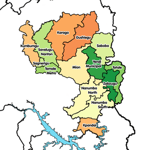
Mion District
| Year dem found am | 28 June 2012 |
|---|---|
| Country | Ghana |
| Capital | Sang |
| Edey de administrative territorial entity insyd | Northern Region |
| Located in time zone | Greenwich Mean Time |
| Coordinate location | 9°25′2″N 0°16′43″W |
| Office head of government hold | District Chief Executive |
| Dey share bother plus | Yendi Municipal District, Saboba District, Gushegu Municipal District, Tamale Metropolitan District, Nanumba North Municipal District |

Mion District be one of de sixteen districts wey dey de Northern Region, Ghana insyd.[1][2][3] Previously, na e dey part of de den Yendi District insyd 1988, na dem create am from de former East Dagomba District Council, e dey der til de western part of de district dem later split off make dem create Mion District for 28 June 2012; den de original part wey remain dem retain am make e cam turn Yendi Municipal District (wey dem elevate am to municipal district assembly status for 29 February 2008). De district assembly dey insyd de central part of de Northern Region den Sang be ein capital town.
Dema Location
[edit | edit source]Ein northern neighbours be Gushegu Municipal den Karaga Districts. To ein east be Yendi Municipal District. De districts wey de border Mion District for de west be Tamale Metropolis, Savelugu Municipal den Nanton District. For de south, edey border Nanumba North District den East Gonja Municipal.
Dema Population
[edit | edit source]According to de 2010 Ghana housing census, de total population for de district be 81,812. E dey mak up of 40,649 males den 41,163 females.
References
[edit | edit source]- ↑ "Mion District to become major Yam market in Ghana". ghananewsagency. GNA. 13 May 2013. Retrieved April 10, 2015.
- ↑ Benson, Ivy (12 November 2013). "Four communities in the Mion district cry for educational facilities". Myjoyonline. Retrieved April 10, 2015.
- ↑ Naatogmah, Abdul Karim (14 March 2015). "Mion District Assembly chases tax evaders". Citifmonline. Retrieved April 10, 2015.

