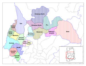
Jaman South Municipal District
| Year dem found am | 12 November 2003 |
|---|---|
| Country | Ghana |
| Edey de administrative territorial entity insyd | Bono Region |
| Coordinate location | 7°35′13″N 2°47′17″W |


Jaman South Municipal be one of de twelve (12) districts wey dey de Bono Region for Ghana. Originally dem know am to be part of de Jaman District for March 10, 1989, afta dem create am from de former Berekum-Jaman District as edey within de then-larger Brong-Ahafo Region. Later on, dem spilt part of de district off wey dem go create Jaman North District for November 12, 2003; thus de remaining original part became Jaman South District.[1] Ebe later wey dem upgrade am to municipal status for November 2017, wey dem rename am as Jaman South Municipal. De municipality dey for de western part of Bono Region wey Drobo be ein capital town.[2]
Edey share common borders plus Berekum West District de south-east, Jaman North District to ein North, Dormaa Municipal to ein south den La Côte d'Ivoire for ein west.[3] De Municipal get total land area of about 700 km2 (270 sq mi) den about 130 settlements most of which be rural communities wey e get population wey be less dan 400.
List of settlements
[edit | edit source]| Settlements of Jaman South District | ||
| Settlement | Population | Population year |
|---|---|---|
| Adadiem | ||
| Adamasu-Adams | ||
| Adinkrakrom | ||
| Amanfoso | ||
| Asantekrom | ||
| Asuokor | ||
| Asiri | ||
| Atuna | ||
| Babianihaa | ||
| Basakrom | ||
| Bonakire | ||
| Buni | ||
| Mayera | ||
| Faago | ||
| Dodosuo | ||
| Dwenem | ||
| Faaman | ||
| Febi | ||
| Goka | ||
| Grobete | ||
| Gyinanko | ||
| Jamera | ||
| Jankufa | ||
| Japekrom | ||
| Jinini Kokoa | ||
| Kaabre | ||
| Kabile | ||
| Kokosua | ||
| Korase | ||
| Kwasibourkrom | ||
| Morle | ||
| Mpuasu | ||
| Gonasua | ||
| Nsonsomea | ||
| Nwamsua | ||
| Ponko | ||
| Sambusi | ||
| Seketia | ||
| Suma Ahenkro | ||
| Yawtwenekrom | ||
| Zobo | ||
References
[edit | edit source]- ↑ "Nineteen New Districts Created". ghanaweb.com. 20 November 2003. Archived from the original on 2 February 2011. Retrieved 22 February 2006.
- ↑ "Berekum GhanaDistricts". Berekum GhanaDistricts Government of Ghana. Retrieved 2020-05-27.
- ↑ "Jaman South Municipal District (Bono Region) Street Guide and Map". ghana-streets.openalfa.com. Retrieved 2024-05-22.

