
Djibouti

| Part of | East Africa, French colonial empire |
|---|---|
| Year dem found am | 23 June 1977 |
| Official name | جمهورية جيبوتي, République de Djibouti, Jabuuti |
| Native label | جمهورية جيبوتي, République de Djibouti, Jabuuti |
| Short name | 🇩🇯 |
| Dem name after | Djibouti |
| Official language | French, Arabic |
| Anthem | Djibouti |
| Culture | culture of Djibouti |
| Continent | Africa |
| Country | Djibouti |
| Capital | Djibouti |
| Located in time zone | UTC+03:00, Africa/Djibouti |
| Located in/on physical feature | East Africa |
| Coordinate location | 11°48′0″N 42°26′0″E |
| Coordinates of easternmost point | 12°7′17″N 43°25′1″E |
| Coordinates of northernmost point | 12°42′0″N 43°7′48″E |
| Coordinates of southernmost point | 10°54′47″N 41°56′48″E |
| Coordinates of westernmost point | 11°29′36″N 41°46′16″E |
| Highest point | Mousa Ali |
| Lowest point | Lake Assal |
| Office held by head of state | President of Djibouti |
| State ein head | Ismail Omar Guelleh |
| Office head of government hold | Prime Minister of Djibouti |
| Government ein head | Abdoulkader Kamil Mohamed |
| Legislative body | National Assembly |
| Central bank | Central Bank of Djibouti |
| Currency | Djiboutian franc |
| Dey share bother plus | Ethiopia, Eritrea, Somalia |
| Driving side | right |
| Electrical plug type | Europlug, Type E |
| Dey replace | French Territory of the Afars and the Issas |
| Language dem use | Modern Standard Arabic, Somali, French, Afar |
| Significant event | Declaration of independence of Djibouti |
| Studied in | Djiboutian studies |
| Dema official website | https://www.presidence.dj/ |
| Hashtag | Djibouti |
| Top-level Internet domain | .dj |
| Flag | Flag of Djibouti |
| Coat of arms | Emblem of Djibouti |
| Geography of topic | geography of Djibouti |
| Get characteristic | not-free country |
| History of topic | history of Djibouti |
| Economy of topic | economy of Djibouti |
| Demographics of topic | demographics of Djibouti |
| Mobile country code | 638 |
| Country calling code | +253 |
| Trunk prefix | no value |
| Emergency phone number | 17, 18, 19 |
| Maritime identification digits | 621 |
| Unicode character | 🇩🇯 |
| Category for maps or plans | Category:Maps of Djibouti |

Djibouti, alias Republic of Djibouti, be sam country for de Horn of Africa insyd, wey edey share border plus Somalia go de south, Ethiopia go de southwest, Eritrea for de north insyd, den de Red Sea den de Gulf of Aden go de east. De country get sam area of 23,200 km2 (8,958 sq mi).[1]
Djibouti be multi-ethnic nation plus population of ova 920,000 (de smallest for mainland Africa insyd). French den Arabic be ein two official languages, Afar den Somali be national languages. About 94% of Djiboutians dey adhere to Islam,[1] wey be de official religion wey na ebe predominant insyd de region for more dan 1,000 years. De Somalis den Afar dey make up de two largest ethnic groups, plus de former dey comprise de majority of de population. Both dey speak language of de Cushitic branch of de Afroasiatic languages.[1]
Politics
Foreign relations
De Djiboutian Ministry of Foreign Affairs and International Cooperation dey manage foreign relations of Djibouti. Djibouti dey maintain close ties plus de governments of Somalia, Ethiopia, France den de United States. Ebe lykwise active participant insyd African Union, United Nations, Non-Aligned Movement, Organisation of Islamic Cooperation den Arab League affairs. Since de 2000s, Djiboutian authorities sanso get strengthened relations plus Turkey.
Djibouti be member of The Forum of Small States (FOSS) since de group ein founding for 1992 insyd.[2]
Administrative divisions

Dem partition Djibouti into six administrative regions, wey Djibouti city dey represent one of de official regions. Dem further subdivide am into twenty districts.
| Region | Area (km2) | Population
2009 census |
Population
2018 estimate |
Capital |
|---|---|---|---|---|
| Ali Sabieh | 2,200 | 86,949 | 96,500 | Ali Sabieh |
| Arta | 1,800 | 42,380 | 72,200 | Arta |
| Dikhil | 7,200 | 88,948 | 105,300 | Dikhil |
| Djibouti | 200 | 475,322 | 603,900 | Djibouti City |
| Obock | 4,700 | 37,856 | 50,100 | Obock |
| Tadjourah | 7,100 | 86,704 | 121,000 | Tadjoura |
Geography
- Landscapes of Djibouti
-
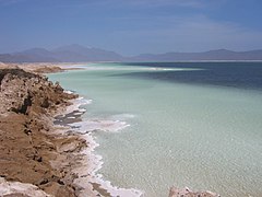 Lake Assal
 -
 Traditional houses for de Mabla Mountains top
 -
 Lake Abbe
 -
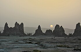
 De mountains near Dasbiyo
 -
 Beach south of Djibouti City, dey overlook de Gulf of Aden


Climate
| Location | July (°C) | July (°F) | January (°C) | January (°F) |
|---|---|---|---|---|
| Djibouti City | 41/31 | 107/88 | 28/21 | 83/70 |
| Ali Sabieh | 36/25 | 96/77 | 26/15 | 79/60 |
| Tadjoura | 41/31 | 107/88 | 29/22 | 84/72 |
| Dikhil | 38/27 | 100/81 | 27/17 | 80/63 |
| Obock | 41/30 | 105/87 | 28/22 | 84/72 |
| Arta | 36/25 | 97/78 | 25/15 | 78/60 |
| Randa | 34/23 | 94/73 | 23/13 | 74/56 |
| Holhol | 38/28 | 101/81 | 26/17 | 79/62 |
| Ali Adde | 38/27 | 100/82 | 26/16 | 80/61 |
| Airolaf | 31/18 | 88/66 | 22/9 | 71/49 |
Demographics
Largest cities
| Largest cities anaa towns insyd Djibouti
According to de 2009 Census[3] | ||||||
|---|---|---|---|---|---|---|
| Rank | Name | Region | Pop. | |||
| 1 | Djibouti | Djibouti | 475,322 | |||
| 2 | Ali Sabieh | Ali Sabieh | 37,939 | |||
| 3 | Dikhil | Dikhil | 24,886 | |||
| 4 | Tadjoura | Tadjourah | 14,820 | |||
| 5 | Arta | Arta | 13,260 | |||
| 6 | Obock | Obock | 11,706 | |||
| 7 | Ali Adde | Ali Sabieh | 3,500 | |||
| 8 | Holhol | Ali Sabieh | 3,000 | |||
| 9 | Airolaf | Tadjourah | 1,023 | |||
| 10 | Randa | Tadjourah | 1,023 | |||
References
- ↑ 1.0 1.1 1.2 "Djibouti". The World Factbook. CIA. 5 February 2013. Retrieved 26 February 2013.
- ↑ 50 Years of Singapore and the United Nations. World Scientific. 2015. ISBN 978-981-4713-03-0.access-date=28 March 2024
- ↑ "Djibouti: Regions, Major Cities & Towns – Population Statistics, Maps, Charts, Weather and Web Information". citypopulation.de.
Sources
- Dis article dey incorporate public domain material from The World Factbook (2024 ed.) CIA. (Archived 2016 edition)
- Ebsworth, W. A. (1953). "Jibouti and Madagascar in the 1939–45 War". Journal of the Royal United Service Institution. 98 (592): 564–68. doi:10.1080/03071845309422199.
- Imbert-Vier, Simon (2008). Frontières et limites à Djibouti durant la période coloniale (1884–1977) (PhD thesis). Université de Provence–Aix-Marseille I.
External links
Djibouti for Wikipedia ein sister projects
- Definitions from Wiktionary
- Media from Commons
- News from Wikinews
- Resources from Wikiversity
- Travel information from Wikivoyage
- Government
- "Site Officiel de la République de Djibouti" [Official website of the Republic of Djibouti] (insyd French). Government of Djibouti.
- "Office National de Tourisme de Djibouti". National Official of Tourism of Djibouti. Archived from the original on 24 December 2018. Retrieved 28 February 2013.
- Profile
- Djibouti. The World Factbook. Central Intelligence Agency.
- Djibouti profile from de BBC News.
- Djibouti web resources GovPubs provide for de University of Colorado Boulder Libraries
- Djibouti at Curlie
- Odas
- The State of the World's Midwifery – Djibouti Country Profile from UNFPA
- Key Development Forecasts for Djibouti from International Futures.
- Wikimedia Atlas of Djibouti
- Djibouti at the Encyclopædia Britannica
- Pages with script errors
- Articles using generic infobox
- Djibouti
- 1977 establishments insyd Djibouti
- Countries den territories wer Arabic be official language
- Countries for Africa insyd
- East African countries
- Former French colonies
- French-speaking countries den territories
- Gulf of Aden
- Horn African countries
- Least developed countries
- Member states of de Organisation internationale de la Francophonie
- Member states of de African Union
- Member states of de Arab League
- Member states of de Organisation of Islamic Cooperation
- Member states of de United Nations
- Republics
- Countries den territories wer Somali be official language
- States den territories dem establish insyd 1977
- Pages using the Kartographer extension